Showing posts with label canyon. Show all posts

Friday, May 31, 2019

Painted Desert, Arizona


My most recent post showed petrified wood at Petrified Forest National Park in Arizona.  The other big attraction at the park is often called the “painted desert”.

The painted desert stretches across much of northern Arizona, so this national park covers just a small portion, but it is easily accessible here.  The brown debris near the center of this photo is probably fragments of petrified logs.


The layers of color were created over millions of years of change in the earth’s surface.  Earthquakes, volcanic ash, and flooding deposited layer after layer of different minerals, and erosion exposed them for us to see.


These hills are known as “the tepees”.


I only had a few hours to explore the park, but I noticed that the best petrified logs are in the south, and the best views of the painted desert are in the north.


The variations of color are just amazing, and this photo gives some idea of the vast uninhabited space around the Park.

There are other attractions in the park including petroglyphs, pueblo ruins, and a Route 66 monument.  It is well worth the trip.

Thanks for looking, but remember that these are copyrighted photos that can not be used without permission, and in most cases a reasonable fee.

Thursday, September 13, 2018

Fantasy Canyon, Utah


Fantasy Canyon is a strange area of eroded gray sandstone about 40 miles from Vernal, Utah.  It covers about 10 acres and has an easy trail.


The entire site is covered with fantastically eroded pillars and gargoyle-like figures.  Early names were the “Devil’s Playground” and “Hades Pit”.


The quartzose rocks of Fantasy Canyon were deposited 38 to 50 million years ago during the Eocene Epoch.  This area was once prehistoric Lake Uinta.


These rocks were on the shore of the lake and different minerals have weathered at different rates, creating the fantastic figures here.


Fantasy Canyon is very fragile.  As old formations erode away, new ones will be formed.


You should be aware that Fantasy Canyon is the territory of pygmy rattlesnakes, although I didn't see any.


Getting there can be tricky.  After driving on good roads for about 35 miles, you turn into a maze of dirt roads in a desert gas field, but the BLM has posted very helpful signs.  We have been told than even a small amount of rain makes these roads impassable, so stay out if clouds are moving in.


As usual, my photos are copyrighted, so please ask for permission before you use them for any purpose.  In most cases, a small fee will be charged.

Thursday, October 12, 2017

St Charles Canyon, Idaho

This has been a strange year for fall color.  It seems that wherever I went I was too early, or too late, or the color just never got very good.  The one exception was St Charles Canyon, just a few miles from home.  I went there on a cold, stormy day with Bruce Gregory and Stephen Johnson who were visiting from California.

The mountain maples were incredible.  They had an amazing variety of colors ranging from yellow to red.  Most of the aspens hadn’t changed yet, so there was some green in the mix as well.


Blue Pond Spring is one of the most beautiful spots in St Charles Canyon, but moose have been known to chase people away from here.  On this rainy day, I had the pond to myself and enjoyed the willow reflections.


Some of the maples were yellow, making nice substitutes for the still green aspens.  They made a beautiful background for the white bark of this aspen.


The green aspen leaves contrasted with the brilliant maples, especially the red ones.

Raindrops looked great on incredibly red mountain maple leaves.

As we left the canyon we stopped to photograph one last scene where a line of maples climbed the canyon wall to the top.  I think the wet stormy weather had a lot to do with the amazing color, and St Charles Canyon was the best we saw this year.

Please respect copyright laws, and do not use my photos without permission.  I will give permission to use photos for educational and charitable purposes, but charge a small fee for personal use.

Friday, May 5, 2017

Shoshone Falls, Idaho

The Niagara of the West.  That’s  one name for Shoshone Falls, but Niagara Falls is “just” 167 feet high, and Shoshone Falls is 212 feet high, and 900 feet across.  Shoshone Falls is sort of a seasonal waterfall on the Snake River near Twin Falls, Idaho.  In the summer it usually has a vastly reduced flow because water upstream is diverted for irrigation, but in the spring it can be booming after a wet winter.  This year we had a huge snow pack, and the falls are roaring.
We visited the falls on a very windy day, and the spray was soaking the observation area of the beautiful city park.  Photography from the nearest observation areas was nearly impossible because the lens was wet as soon as the cover was removed, so this photo was taken a bit further away.  Even so, I had to wait for a moment when the mist was at a minimum and hurry to take the picture.


The mist and bright sun combined for wonderful rainbows.


The rainbow framed the Snake River Canyon when Linda and I returned the following morning.  We hoped that there would be less wind, therefore less mist, and drier conditions for photography.  Wrong, but at least we saw the rainbow from a different angle because we were so much earlier in the day.
If anything, the wind was worse, and instead of the observation area being soaked, the entire city park was drenched.   The best we could do was remove the lens cover, take a quick shot or two, and slap the cover back on.  Then find someplace dry to clean the lens.  Then try again. 
 Even seen through the mist, the power of these magnificent falls was astonishing.  If you go, try to be there between April and July during a wet year.

Please note that these photos are copyrighted and cannot be used without permission.  We usually request a small payment depending on usage.

Saturday, June 11, 2016

Palouse Contours, Washington

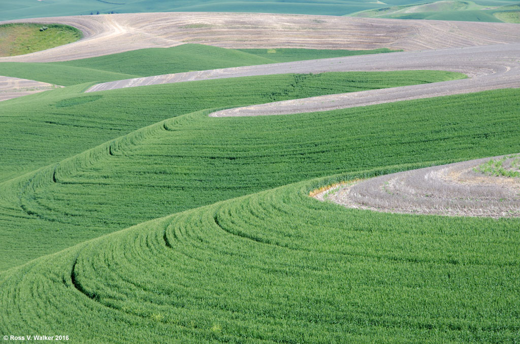
The Palouse region of Washington is a remarkably beautiful area of rolling hills and well-kept farms.  Photographers enjoy patterns of green fields cultivated along the curves of these hills.  This is my second post from my recent trip with Linda.


We explored several areas looking for patterns in the cultivated hills.  These two photos were taken near Almota on the edge of the Snake River Canyon.  They are pretty good examples of how many of the fields are farmed wherever the hills aren’t too steep for machinery.  In fact, in many parts of the Palouse, special hillside combines are used.


These two photos were taken along back roads near Steptoe.  You can see what a wonderful effect cloud shadows have on the rolling hills.  Back roads are the best way to explore the Palouse because it is easy to stop anywhere without worrying about traffic.


The last two were taken very close together near the small town of St  John.  Very often two crops are planted on the same hill, for example, rows of garbanzo beans over wheat.  This often results in beautiful stripes or contrasting patterns.  This early in the year we found many fields with unplanted layers over lower bands of green.

It is a good idea to visit the Palouse in different seasons.  In the fall, harvest time brings out the big combines, and winter may add snow drifts to the curves.  The spring curves of new crops were just gorgeous.

Please respect my copyright, and do not use these photos without permission.

Sunday, December 27, 2015

Fremont Indian State Park, Utah

In October 2015 I went on a fall camping trip with my California photography friends.  We met in Ely, Nevada then traveled to Delta, Utah to explore Topaz Japanese Internment Center (see the next post) and the Tintic Mining District.  The last stop was Fremont Indian State Park, Utah, to photograph the Kimberly Mining District and rock art at the Park.

The Fremont Indians lived in central Utah and the surrounding area from about 400 A.D. to 1300 A.D.  It is likely that there were several different tribes, and they may have even had different languages, but their rock art and artifacts set them apart from the nearby Anasazi tribes.  Their culture was named for the Fremont River, which was in turn named for explorer John C. Fremont.
There are hundreds of rock art panels in the park, and we explored several different sites.  One of the most interesting is the Beginning of Life panel located in the Canyon of Life.  Rock Art interpretation is an inexact science, but a Park trail guide states that this petroglyph describes the shape of the canyon and a legend about the sun conceiving life from the east and the west.  Briefly, the sun is shown with its rays, and the center hole represents a natural tunnel in the east side of the canyon.  The sun penetrated the hole and conceived life.  At noon on the summer solstice, a dagger of sunlight goes from the center of the hole to the outer rim of the circle.


The park is in a beautiful location with red rock cliffs, a creek, and views of the Tushar mountains.  We were there in autumn and I enjoyed the fall color in Sam Stowe Canyon and the brilliant squawbush leaves on the Cave of a Hundred Hands trail.


There are actually just 31 hand pictographs in the Cave of a Hundred Hands.  They were made by applying various pigments to the hands and pressing them against the stone.  I posted this photo to Flickr, and received a comment that this is “the most personal kind of pictograph.”  I had never thought of it that way, but now I can imagine the Indians kneeling here as they placed their hand prints on the cave wall.


Petroglyphs along the Parade of Rock Art trail are the most accessible in the park.  This hunting scene shows bighorn sheep, which are common rock art subjects throughout the Fremont culture.  But excavations turn up lots more deer, waterfowl, and rabbit bones than sheep.  Were superstitious artists trying to make the sheep easier to kill by pecking their images in the rock?  Or was a rare successful sheep hunt a reason to brag by creating sheep petroglyphs?


There are also much newer Paiute petroglyphs on the Parade of Rock Art trail.  What could have inspired this “alien” figure?  It was probably created in the late 1880’s.  Older petroglyphs are gradually darkened by oxidation called desert varnish, and since this has no desert varnish we know it is much newer than the Fremont petroglyphs.


The Court of Ceremonies trail is a little more challenging; with a short rock scramble and a brief climb to a ridge that has a good view of the visitor’s center and the Tushar mountains.  There are several interesting anthropomorph (stylized human figure) petroglyphs on the cliffs along the trail.
We also explored the Arch of Art and Sheep Shelter rock art locations, and there were many others that we didn’t get to.  This park is a great place for a family trip to introduce kids to interesting western art and history.  If you would like to see more photos, my Flickr album is here:

Please note that my photographs are all copyrighted and must not be used for any purpose without my permission.

Tuesday, April 1, 2014

Winter in Bear Lake Valley, Idaho - 2014

On January 18th I posted photos of the amazing hoar frost we had here in the valley this winter.  This was an exceptionally beautiful winter in the Idaho end of the valley, so now that spring has arrived, I thought I would post a few scenic photos from winter days that didn't have that gorgeous frost.
The Rearing Pond in Montpelier Canyon is a favorite photo stop, but I don't think it ever looked better than on this day.
Conditions could be harsh, and this scene on the edge of Montpelier was a challenge because of strong winds and blowing snow.
One morning in late winter I saw these low clouds and hurried down the street to this abandoned house.  I think it was a great subject for a black and white photo.
The Bear River between Georgetown and Nounan was beautiful when the ice started to melt and the transition to spring started.  Most people are ready for spring, but I will miss the clean beauty of winter in the Bear Lake Valley.

Tuesday, September 25, 2012

Lamoille Canyon, Nevada

There are places in this country that are every bit as beautiful as most National Parks, but are nearly unknown by most Americans. Lamoille Canyon is one of those special places.
The canyon is the largest valley in the Ruby Mountains south of Elko, Nevada.  It was carved by glaciers, and usually has snow fields and waterfalls year round.  We missed them because of the dry year.


Wildlife includes beavers, and their ponds create reflective pools that are great for photographing the massive canyon walls. There are also bighorn sheep and mountain goats.


The canyon walls soar 2000 feet above the valley floor so sunlight hits some of the cliffs while others are in shadow.  The sheer rock walls remind me of Yosemite Valley.
The morning view in the beautiful campground included this dagger of light when the early sunlight touched the ridge.

The morning light bounced off a mountain and reflected in the water of the creek next to my campsite.  In the space of one second, the color disappeared when the sunlight reached the water. The rocks in this photo were in shadow, and they picked up the reflected blue of the sky.
The road through Lamoille Canyon is paved and 12 miles long. For you younger, more energetic kids, there are miles of  trails. The campground is excellent and there are motels and restaurants in nearby Elko. Don't miss the Basque food at the Star Hotel!

Monday, March 26, 2012

Mountain Goats

Mountain goats are often seen in the Snake River Canyon near Alpine, Wyoming.  It isn't unusual to see a few fairly close to the road in winter, but when we were there, they were a long way up the mountain.
Several members of our Sharp Shooters Camera Club have taken beautiful close-up photos of these interesting animals, but I wasn't so lucky.  However, I was extremely fortunate to see a huge herd of over 75 goats grazing their way across the mountain.  The snow had just about melted, so I suppose they were taking advantage of the bare ground to find food.

The herd was scattered over a wide area and was gone in about a half hour.  This huge herd was probably a nursery group of nannies (females) and kids.  The billies (males) usually form much smaller groups and keep to themselves.  These photos show just a small part of the widely scattered herd.  As the weather warms up they will head for higher elevations and won't be seen again until next winter.