Showing posts with label Nevada. Show all posts

Friday, October 27, 2017

Monarch Mine, Nevada

After leaving Sprucemont, Nevada (see the previous post), we continued up Spruce Mountain about two more miles.  The road got much rougher, although it was not nearly as difficult as we expected.  I did use four-wheel drive, and in one or two places low range, and was glad I recently added skid plates to my truck.

Our first view of the mine area included a few houses along a side road.  The area is very steep, with houses on different levels of the hillside.

Most of the buildings are frame houses, but there is one cabin made from massive logs that probably dates back to the earliest days of the mine, around 1899.

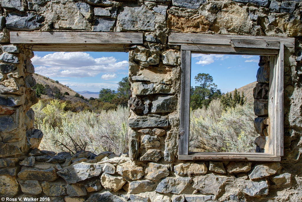
This is a true ghost town.  Many buildings are totally collapsed, and those that are still standing have a lot of damage.  Some look like they were nice at one time, but now the wallpaper is peeling and the ceilings coming down.  But, their positions high on the mountains had great views from the windows.


There is a huge crumbling ore bin right in the middle of the residences, and a mine shaft nearby, so miners didn’t have to go far to work.  The gigantic timbers were held together with massive nuts, bolts, and square washers.  Now many are gone, and others are beautifully rusty.

The Monarch Mine was a big producer of lead during World War I.  According to the USGS website, 

"About $200,000 worth up to 1902; 21,000 tons ore worth $475,000 from 1919 to 1921; more production through 1952. Total production was over $1,000,000 worth, including some zinc and copper."

This photo gives some idea of how steep the mountain is, and how houses were built on plots leveled out of the hillside.  We enjoyed exploring the townsite, but didn’t stay long because snow flurries started, and we were a long way from pavement.  The Spruce Mountain mining area was well worth the visit.

I hope you enjoy the photos, but please respect the copyrights and do not use them for any purpose without permission.

Tuesday, October 24, 2017

Sprucemont, Nevada

We were on our annual fall camping trip with plans to explore ghost towns in Montana.  Then the weather went bad and we decided to migrate south.  We spent a day in Wells, Nevada and searched for ghost towns in the Spruce Mountain mining district.

We were looking for Sprucemont, about 10 miles from the nearest paved road, and got into a maze of dirt roads on Spruce Mountain.  When the roads got worse we decided to turn around and look for another route, and I spotted the remains of this log cabin high on a nearby ridge.  It is an unusual double cabin, which makes me think it could have been part of a string of businesses along the town’s main street.  The other side of the cabin has collapsed, and most of the dirt roof is gone.

We looked uphill and saw other structures.  These were much newer frame buildings, which had all been vandalized, and a few had totally collapsed.  The weather was heavily overcast with a storm moving in, so the light wasn’t very good, but then the clouds broke, and I got a decent photo of this old house.

Sprucemont began about 1870 when several mines were started on Spruce Mountain.  By 1887 there were five saloons here, but just a year later, mines were closing and Sprucemont was nearly deserted.  In 1899 the Monarch Mining Company was started, and Sprucemont came to life, but was again nearly deserted by 1913.  In the 1930’s a third period of mining started, and continued through about 1952.  By 1961 the district had ceased all production.  This helps explain the different building styles we see at Sprucemont.  The big log cabin likely dates from the first or second era, and the frame buildings from the third.

The people who lived in Sprucemont had a million-dollar view of the East Humboldt range. The cloud shadows crossing the valley seemed to emphasize the immense space of the valley at the base of Spruce Mountain.

From here we continued up the mountain to find the Monarch Mine.  I will try to post that adventure in a few days.

Please remember, these photos are copyrighted.  I will allow them to be used for charitable purposes, but charge reasonable fees for personal use.

Monday, October 24, 2016

Humboldt City, Nevada

About 500 people lived here once, but Humboldt City has been a ghost town since the post office was removed in 1869.  Silver was discovered here in 1860, and the city was built here to support several mines.  But, it didn’t last long.
A dirt road runs from the valley through the center of town.
Humboldt City is located along a creek that runs through a canyon high on a mountain in the Humboldt Range of Nevada.  There were 200 buildings here, and now you can still find many rock ruins scattered through the underbrush and on the hillsides.
Some of them, like this one with the double windows, have signs that people tried to move in here long after the city was abandoned.  We found a cinder block fireplace added to this old rock wall.
This cabin also has some modern materials like rusty window screens.  It was hard to get to because it was built in a deep gully next to the creek.  I don’t understand why it wasn’t washed away years ago.
There were two hotels here; the Coulter House and the Iowa House.  I’m guessing that this ruin was one of them because of the large front room and a smaller room in back that could have been a kitchen.
The view from the hotel looked up the canyon toward the mountains where the mines were located.  It looks like it has been a long time since the last “No Vacancy” sign went up.

Humboldt City is just a couple of miles from busy Highway 80, near Mill City, Nevada, but being there is like being in a different world.

Remember, all my photos are copyrighted.  Please do not use them for any purpose without permission.

Sunday, October 13, 2013

Tunnel, Nevada - Ghost Town

Tunnel, Nevada is one of the best true ghost towns I have ever seen.  I was there with Bruce Gregory and Stephen Johnson, camping buddies for the last 32 years.
Tunnel has it all.  It is in a remote location north of Lovelock, is completely deserted, and has several intact buildings, as well as this photogenic old truck.

Tunnel is one of the only places where I have found an intact stamp mill on site.  These things are usually found only in museums.

Tunnel was founded in 1927 and named for an attempt to bore a tunnel from Seven Troughs on the other side of the mountain to improve drainage and help move ore to a mill on site.  Veins of gold were found in the 2 1/2 mile tunnel.


Perhaps this brick building was a power plant or office building for the Nevada State Mining Company.  Vandals have severely damaged the walls and roof.


There is a human factor seen here.  It is the only ghost town where I have found clothes still hanging on the wall in an old cabin.

The cemetery has 13 graves with wood and metal crosses.  There are no names or dates on any of the markers.  Who were these people?  What happened to them?

Was this an assay office?  There are hundreds of bags of ore samples inside, but of course they have been broken open and scattered everywhere.

There isn't a lot of information about Tunnel, but I understand that water in the tunnel brought an end to mining in the 1950's.

Tuesday, April 30, 2013

Little Planets

Here's a fun creative Photoshop project that is much easier than it looks.  To get your attention, I will start by showing you the end product, then describe how it was done.  My title for this photo is "America On A Stick".  It was taken in an area of Wells, Nevada that was destroyed by an earthquake in 2008.  An American flag has been painted on a wall next to ruins that have been neglected ever since the earthquake.
I used Photoshop Elements version 9 for this project.  The hardest part of this is to pick a photo that will work well.  It helps to have a photo that has sky colors that match on the left and right edges, and a horizon that is the same height on each edge.  Here is the original photo:
I rotated this photo left 2.5 degrees (Image > rotate > custom) to get the tops of the far left and far right buildings even, then cloned out the power line across the sky.  It helps to overlay a grid across the image to get it even (View > Grid).  The next step is to rotate the adjusted image 180 degrees (Image > rotate > 180)
The next step creates the Little Planet.  The results are pretty unpredictable, so it is always kind of exciting to see what happens.  Filter > Distort > Polar Coordinates.  Select "Rectangular To Polar" and click OK.
Next, fine-tune the image.  In this case, I chose to rotate it back so that the lamp post was on the bottom.  I also blended the line in the sky and some other parts of the same line using the healing brush and clone stamp tools.  Many images will have distracting patterns in the corners that you may want to crop out or retouch.  The final image, as seen in the beginning of this post, was stretched to a circle.  Resize > Image Size, then uncheck "constrain proportions" and type in new dimensions so that width and height are equal.  Finally, crop, retouch, and adjust as desired to get your masterpiece.

Tuesday, September 25, 2012

Lamoille Canyon, Nevada

There are places in this country that are every bit as beautiful as most National Parks, but are nearly unknown by most Americans. Lamoille Canyon is one of those special places.
The canyon is the largest valley in the Ruby Mountains south of Elko, Nevada.  It was carved by glaciers, and usually has snow fields and waterfalls year round.  We missed them because of the dry year.


Wildlife includes beavers, and their ponds create reflective pools that are great for photographing the massive canyon walls. There are also bighorn sheep and mountain goats.


The canyon walls soar 2000 feet above the valley floor so sunlight hits some of the cliffs while others are in shadow.  The sheer rock walls remind me of Yosemite Valley.
The morning view in the beautiful campground included this dagger of light when the early sunlight touched the ridge.

The morning light bounced off a mountain and reflected in the water of the creek next to my campsite.  In the space of one second, the color disappeared when the sunlight reached the water. The rocks in this photo were in shadow, and they picked up the reflected blue of the sky.
The road through Lamoille Canyon is paved and 12 miles long. For you younger, more energetic kids, there are miles of  trails. The campground is excellent and there are motels and restaurants in nearby Elko. Don't miss the Basque food at the Star Hotel!

Sunday, September 16, 2012

Metropolis, Nevada Ghost Town


Summer was way too busy to find time for updating this blog, but a camping trip last week included a photo opportunity that I just had to post.  I was on the way to Elko, Nevada to meet a friend for our second camping trip this year, and our 31st consecutive year of camping and photography.  I took a side trip north of Wells, Nevada to the ghost town of Metropolis.  This was a planned farming community started in 1910, with irrigation provided by a dam on Bishop Creek.  However, the planners never bothered to get water rights and were sued by the town of Lovelock, Nevada.  When Metropolis lost their water, the residents gradually moved out, and Metropolis was a ghost town by 1950.
The most spectacular ruin is the arch of the old Lincoln school.  The town once had a railroad station and daily passenger service, but there is no trace of the station.
This is the basement of the ruined school.  Spooky, to say the least.  Someone has shored up the stairs with a couple of 2 x 6's, and there are ceiling holes everywhere, but the debris-filled space is a ghost town classic.

The other major ruin was once a hotel.  Notice how isolated this place is.  There are miles of treeless sagebrush plains in every direction.  There is probably a cemetery somewhere, but I couldn't find it.
If you wander through the sagebrush, you will find a few foundations, the usual small artifacts like broken glass, and this wonderful rusty wreck.  There used to be a city here, with houses, stores, and about 700 people, but the desert has reclaimed nearly everything.

Friday, July 22, 2011

Thunder Mountain, Nevada

Thunder Mountain... the name sounds like some high Sierra location in the wilderness, but it is much more difficult to descibe.


Thunder Mountain Indian Monument is a State of Nevada historic site.  Bizarre, artistic, eclectic, artsy, and even kind of scary, Thunder Mountain is a collection of faces, towers, junk, statues, old cars, and buildings made from concrete, bottles, windshields, typewriters, and whatever other building materials the artist could find.


The creator of the monument was Frank Van Zant who later in life called himself Chief Rolling Mountain Thunder.  He described his creation as a monument to the American Indian.  During his life he was a World War II veteran, assistant pastor, sheriff's deputy, and private investigator, but inspired by a bottle house he had seen in the desert, he moved his family to rural Imlay, Nevada and created his unusual home.

A bottle wall seen from the inside. 


                                                                                                                                                                  Nightmarish faces, deteriorated by years of exposure, are found everywhere you look, peering out from corners or towers, and a Madonna seems to watch you from behind a wire fence.  Native American symbolism is everywhere, but other symbols are harder to understand, like an amazing human / butterfly.  The site is deteriorating, but the artist's son is trying to preserve and restore it.  There is a caretaker on the site, and he gladly let us inside the fence to take photos.  There is no charge, but donations are accepted and welcome.