Showing posts with label clouds. Show all posts

Tuesday, February 19, 2019

Bear Lake Monster Encounter


I should have written about my encounter with the Bear Lake monster just after it happened, but I didn’t want trouble from the skeptics.  But since Idaho Magazine published my article about the event in the February 2019 issue, the secret is out.  I might as well talk about it.

It was a dark and stormy night.  Well actually, evening just after sunset, and Linda and I were camped at Bear Lake State Park on the east side of the lake in Idaho during July 2018.  A storm was dropping beautiful sheets of rain on the western mountains across the lake.  I set up my camera on a tripod to photograph the storm and hopefully get a lightning strike.  It got darker and darker, so my exposures got longer and finally I got a photo of some lightning.  The wind got stronger, indicating the storm was getting closer, so I knew I had to leave to avoid the lightning.  But just as I got ready to pack up the tripod I saw something leaping and bounding across the water coming right at me!  My first thought was the famous Bear Lake monster was coming to get me.  What else could it be?

I started taking photos as it got closer and closer, but it was dark and my photos of the charging monster were all blurry because of the long exposures.  The monster hit the beach nearly at my feet.  It was a giant black inflatable turtle that must have blown all the way across the lake from the west shore eight miles away.  Heart pounding, I packed up my gear and returned to our trailer just as the rain hit.


During the night a second thunderstorm hit, and when I looked for the turtle the next morning it was gone.  The wind must have blown it to Wyoming.

I’m glad the folks at Idaho Magazine thought enough of this yarn to publish it, and I got a kick out of telling the story.

Please remember, my photos are copyrighted and must not be used without permission.  I usually charge a reasonable fee to use them, except for charitable or academic purposes.

Saturday, February 9, 2019

Sun Dog


A sun dog is an atmospheric phenomenon that creates patches of light about 22° to the side of the sun.  Usually we see them on cold clear mornings here in the Bear Lake Valley, but this one showed up in the middle of a misty afternoon.

Suns dogs, or parhelia, are created by sunlight refracting through icy clouds of hexagonal crystals.  I was out looking for photo opportunities with Bruce Grayum when we saw this one from a back road near Georgetown, Idaho.  The cows didn’t seem impressed by the huge apparition in the sky near their pasture, but they did provide scale to show the size the sun dog.
It was a cold day, 9° F as we continued to explore.  We stopped at the bridge over the Bear River on the Nounan road and saw the sun dog again, but this time no clear sky was visible at all.  I liked the reflected light in the river.
Sometimes the arcs of light form a complete halo around the sun, and some have faint rainbows of color like this one.  Photographing them can be tricky because the camera must be pointed directly at the sun.  A clean lens is needed to prevent flares, and there is danger of getting a burned retina.  If your camera has it, live view might be a good option.
Our last stop was along Creamery Lane between Georgetown and Nounan where the sun dog appeared in icy mist over a winter landscape of drifts and sagebrush.  Shooting into the sun causes the lens to stop down, darkening the photo, but if the exposure is lengthened, the sun dog seems to blend with the sky and disappear.  I think the darkened exposure presents an other-worldly appearance anyway.

Why are they called “sun dogs”?  No one knows for sure, but the term has been around since the 1600’s and the origin seems to be lost in time.  Some say it is because the "dogs" follow the sun around.

I hope you like this post, but please do not use my copyrighted photos without permission.

Tuesday, October 24, 2017

Sprucemont, Nevada

We were on our annual fall camping trip with plans to explore ghost towns in Montana.  Then the weather went bad and we decided to migrate south.  We spent a day in Wells, Nevada and searched for ghost towns in the Spruce Mountain mining district.

We were looking for Sprucemont, about 10 miles from the nearest paved road, and got into a maze of dirt roads on Spruce Mountain.  When the roads got worse we decided to turn around and look for another route, and I spotted the remains of this log cabin high on a nearby ridge.  It is an unusual double cabin, which makes me think it could have been part of a string of businesses along the town’s main street.  The other side of the cabin has collapsed, and most of the dirt roof is gone.

We looked uphill and saw other structures.  These were much newer frame buildings, which had all been vandalized, and a few had totally collapsed.  The weather was heavily overcast with a storm moving in, so the light wasn’t very good, but then the clouds broke, and I got a decent photo of this old house.

Sprucemont began about 1870 when several mines were started on Spruce Mountain.  By 1887 there were five saloons here, but just a year later, mines were closing and Sprucemont was nearly deserted.  In 1899 the Monarch Mining Company was started, and Sprucemont came to life, but was again nearly deserted by 1913.  In the 1930’s a third period of mining started, and continued through about 1952.  By 1961 the district had ceased all production.  This helps explain the different building styles we see at Sprucemont.  The big log cabin likely dates from the first or second era, and the frame buildings from the third.

The people who lived in Sprucemont had a million-dollar view of the East Humboldt range. The cloud shadows crossing the valley seemed to emphasize the immense space of the valley at the base of Spruce Mountain.

From here we continued up the mountain to find the Monarch Mine.  I will try to post that adventure in a few days.

Please remember, these photos are copyrighted.  I will allow them to be used for charitable purposes, but charge reasonable fees for personal use.

Saturday, June 11, 2016

Palouse Contours, Washington

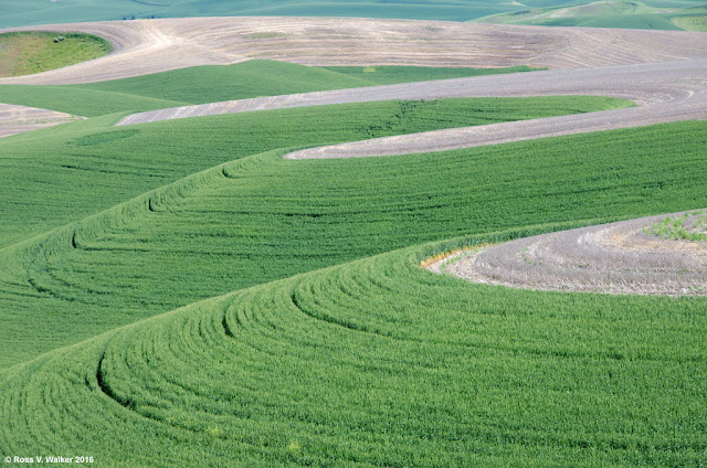
The Palouse region of Washington is a remarkably beautiful area of rolling hills and well-kept farms.  Photographers enjoy patterns of green fields cultivated along the curves of these hills.  This is my second post from my recent trip with Linda.


We explored several areas looking for patterns in the cultivated hills.  These two photos were taken near Almota on the edge of the Snake River Canyon.  They are pretty good examples of how many of the fields are farmed wherever the hills aren’t too steep for machinery.  In fact, in many parts of the Palouse, special hillside combines are used.


These two photos were taken along back roads near Steptoe.  You can see what a wonderful effect cloud shadows have on the rolling hills.  Back roads are the best way to explore the Palouse because it is easy to stop anywhere without worrying about traffic.


The last two were taken very close together near the small town of St  John.  Very often two crops are planted on the same hill, for example, rows of garbanzo beans over wheat.  This often results in beautiful stripes or contrasting patterns.  This early in the year we found many fields with unplanted layers over lower bands of green.

It is a good idea to visit the Palouse in different seasons.  In the fall, harvest time brings out the big combines, and winter may add snow drifts to the curves.  The spring curves of new crops were just gorgeous.

Please respect my copyright, and do not use these photos without permission.

Wednesday, June 8, 2016

Palouse Barns, Washington

Linda and I got away for a week in the beautiful Palouse region of Washington.  I plan to publish at least three posts from this trip, and possibly more.  One of the sights we enjoyed was the abundance of barns.


This was one of my favorites.  It was in a quiet location near Manning.  The grounds are beautiful, with a manicured lawn and wild roses in the foreground. 


When photographing barns, it helps to include the setting instead of taking an ordinary close-up of the building.  Each barn has a photographic story.  This one somewhere on a back road near Colton is isolated in a field.  Notice that there are no roads or paths leading to the barn, so perhaps it is unused and abandoned.


The Dahmen barn in Uniontown is special.  It is surrounded by a fence made of over 1000 wheels and gears.  The restored 1935 barn houses the work of many first rate artists, including photographers.  We could have spent hours photographing this barn and fence.


One of the things I really enjoyed about these barns was how neat everything is.  The grounds of active farms were almost always immaculately kept, with no junk around.  This was true nearly everywhere we went in the Palouse.  Often, older equipment was restored and displayed on the property, like this color coordinated truck in Uniontown.


We spent a lot of time on back roads, and discovered a few abandoned farms.  This property included a house, outhouse, two combines, and other abandoned machinery.  The surrounding fields were still being cultivated even though these buildings were abandoned.   It was much easier to stop on the back roads and take pictures when we weren’t fighting busy traffic and looking for a place to pull over.


Clouds and shadows made a big difference.  This old barn near Colton wasn’t too exciting since the surrounding fields were bare dirt, but when clouds moved in, the shadows transformed the scene.


The back roads around Colton were just loaded with beautiful barns.  We were delighted to see two together here, and a low viewpoint added the cattle guard for extra interest.

The toughest part of this post was selecting some favorites out of the dozens we stopped to photograph.  The Palouse may not be a big tourist destination, but it sure is a great place for photography.

Please be aware that all my photos are copyrighted, and cannot be used without my permission.