Sunday, April 3, 2016

Greater Sage-Grouse

Jim Parker has been responsible for some of my best adventures in the Bear Lake Valley, Idaho area, and this one is near the top of my list.  Every spring the greater sage-grouse gather together and put on a courtship display in areas called leks.  These are relatively clear areas in the sagebrush where groups of males can do their best to attract the females.  The lek locations are not publicized to avoid conflicts with people.
Jim is really good at tracking down interesting things to photograph.  He picked me up at 6:15 AM and we drove to an area where he had seen grouse the previous day.  It was well before sunrise when we got there, and there were no grouse.  An hour or so 
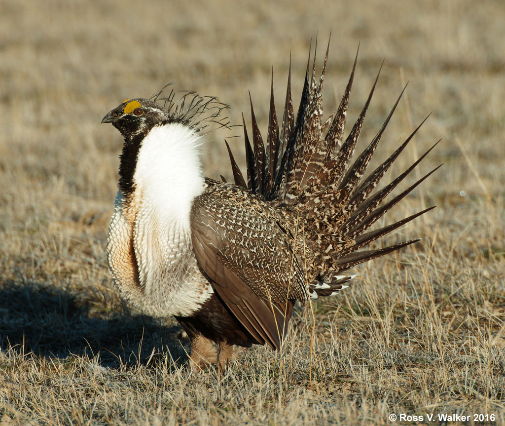
later, the sun came up and we saw a few in the distance.  They were easy to see because of their bright white collars.  Jim put his truck in 4wd to drive across country where we found a lek with dozens of male sage-grouse.
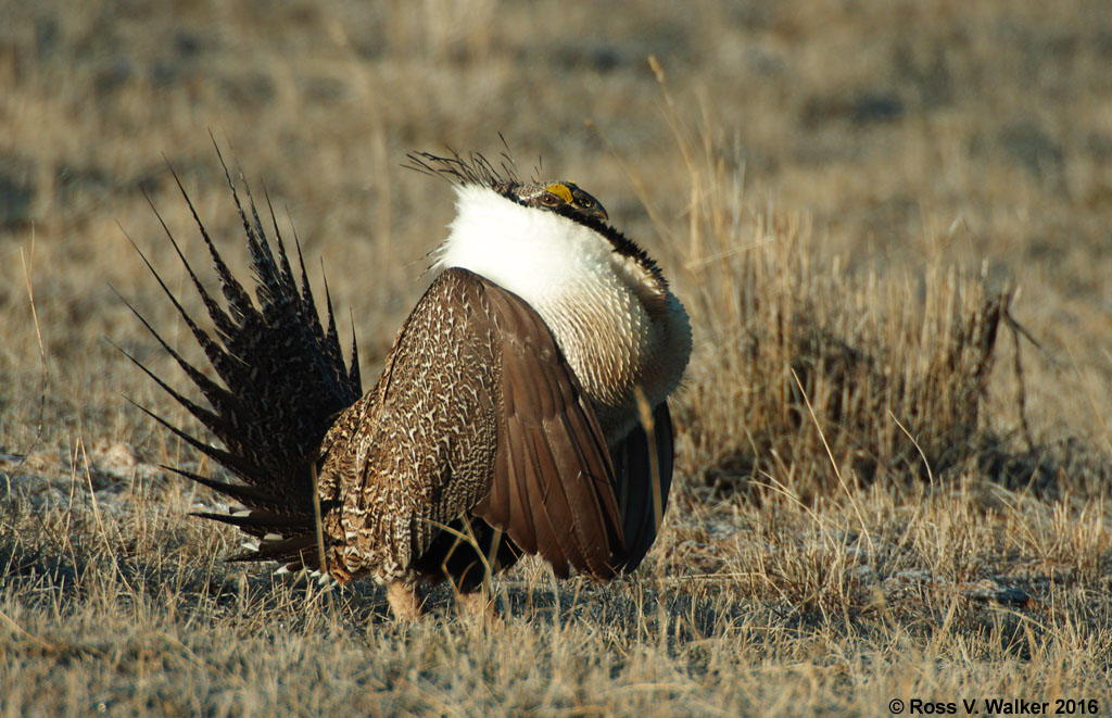
The males put on a wonderful display, fanning their tails, strutting, and inflating air sacs in their chests.  Sometimes their heads almost disappeared into their feathers because the air sacs were so big.  They deflate these sacs with an audible POP, which I suppose is meant to be irresistible to the hens.
We were very close to the action, but most of the males didn’t seem to care and continued with their displays, but the females kept their distance.  After a half hour of watching and taking pictures we left, and we hope that the cautious hens came to the lek in response to these remarkable displays.  Just one or two dominant males will mate with all the females, so presenting an impressive display is really important.
The greater sage-grouse was considered for placement on the endangered species list, but that would have had a big impact on ranching, oil and gas exploration, etc.  An effort to improve sagebrush habitat had a positive impact on sage-grouse survival and avoided placement on the list, at least for now.

Please note that my photos are copyrighted and must not be used without my permission.

Monday, February 29, 2016

Ice Blocks and Hoarfrost

My January 12, 2016 “Mysterious Ice” post was in about this same location.  At that time, the ice was piled up in delicate sheets about a millimeter thick.  Now, huge blocks of ice have blown against North Beach jetty at Bear Lake State Park, Idaho.


Tons of ice stacked up here, and after a few days they were covered with hoarfrost.


Most of the piles of ice reached five to seven feet above the surface of the lake, but this one was at least ten feet high.  Backlighting by the sun really made the blue color of the ice stand out.


This photo was taken from about the same location as the opening photo from my January 12 post.  The boulders have been covered by the blocks of broken ice.


I noticed a delicate feather trapped in one of the ice blocks.  Access was difficult because it was in a little alcove in the ice, and I had to kneel on a jumble of slippery ice blocks.  There must have been billions of tiny hoarfrost crystals.  These photos were taken with a Tamron 90mm macro lens. 


There are a few open leads in the ice at the north end of the lake, but most of the lake is still covered with ice.  It will be interesting to see what happens when it warms up, especially if there is a strong wind to blow the ice to the shore.  This could be an exciting spring.

Please note that my photographs are copyrighted, and you cannot use them for any purpose without my permission.

Monday, February 8, 2016

Elk at Hardware Ranch

Our Sharp Shooters Camera Club went on a field trip to Hardware Ranch in Utah last Saturday to photograph a big herd of elk up close and personal.


This has got be one of the best deals anywhere for family entertainment.  This year there are about 400 elk at the ranch, and we rode a horse-drawn sleigh to see them, for just $5.00 each.


There are many more cows than bulls on the ranch, and the ladies seem to be good at ignoring this bull.  We were told that about 80% of the cows are pregnant, and they need to eat more than the bulls, so they are more likely to come down to the feeding grounds.  All the elk will leave when the snow melts and food becomes available in the mountains again.


Elk need to leave the mountains to find food in the winter, and most of their historic feeding areas no longer exist because of development.  Hardware Ranch, and many other locations in the Rocky Mountains, has been established to grow hay during the summer and provide food for the elk in winter.


This little guy is an elk calf.  It may look small, but an adult bull Rocky Mountain elk (wapiti) can weigh 700 pounds.  The elk here are completely wild and unfenced, so getting this close is a great opportunity.


This is the largest bull elk on the ranch at the moment.  His massive antlers are really impressive, but will shed by the end of winter.  Antler size is determined by age, nutrition, and genetics.


Why do the elk tolerate sleighs full of people?  Our guide said she thinks they are used to being fed from a sleigh so they don’t associate them with danger.  But, if someone gets off the sleigh so the elk see a human shape, they run off in a hurry.  In fact, our sleigh lost a “tug” which had to be reattached.  A second sleigh was placed alongside so the repair could be done while hidden from the elk.  None of this could be done without the beautiful, patient draft horses, and they seem to like attention after each ride.


I recommend Hardware Ranch as a great family destination in the winter.  The kids will love it.


Please note that these photos are all copyrighted and should not be used without my permission.

Tuesday, January 12, 2016

Mysterious Ice At Bear Lake, Idaho

Winter is a beautiful time to photograph Bear Lake in Idaho and Utah.  The lake freezes over only about seven out of ten years despite the very cold winters.  Yesterday Bruce Grayum and I went to one of my favorite locations at Bear Lake State Park on the Idaho end of the lake.
I had trouble understanding what I was seeing when I looked down on the lake from the North Beach jetty.  There were mysterious streaks across speckled gray areas of ice.  I could hear faint, almost musical tones coming from the lake.
I walked down the boat ramp and around the shore, and discovered that the streaks were caused by a thin layer of ice being blown over thicker stationary ice.  The thicker, gray ice had beautiful frost crystals that were being wiped out by the moving thin layer of ice.
The noise I had heard was the windblown thin ice breaking and stacking against the shore.  It was no more than a millimeter thick, so the broken, glass-like ice was very sharp.
I don’t know if this thin ice will be enough to trigger a complete freeze of Bear Lake as long as the wind keeps shifting it around, but this is not what I am used to seeing here.  In previous years there have been blocks of ice like boxcars along the shore.  There always seems to be something new to see at Bear Lake.

I hope you enjoyed these copyrighted photos.  Please do not use them without my permission.

Sunday, December 27, 2015

Fremont Indian State Park, Utah

In October 2015 I went on a fall camping trip with my California photography friends.  We met in Ely, Nevada then traveled to Delta, Utah to explore Topaz Japanese Internment Center (see the next post) and the Tintic Mining District.  The last stop was Fremont Indian State Park, Utah, to photograph the Kimberly Mining District and rock art at the Park.

The Fremont Indians lived in central Utah and the surrounding area from about 400 A.D. to 1300 A.D.  It is likely that there were several different tribes, and they may have even had different languages, but their rock art and artifacts set them apart from the nearby Anasazi tribes.  Their culture was named for the Fremont River, which was in turn named for explorer John C. Fremont.
There are hundreds of rock art panels in the park, and we explored several different sites.  One of the most interesting is the Beginning of Life panel located in the Canyon of Life.  Rock Art interpretation is an inexact science, but a Park trail guide states that this petroglyph describes the shape of the canyon and a legend about the sun conceiving life from the east and the west.  Briefly, the sun is shown with its rays, and the center hole represents a natural tunnel in the east side of the canyon.  The sun penetrated the hole and conceived life.  At noon on the summer solstice, a dagger of sunlight goes from the center of the hole to the outer rim of the circle.


The park is in a beautiful location with red rock cliffs, a creek, and views of the Tushar mountains.  We were there in autumn and I enjoyed the fall color in Sam Stowe Canyon and the brilliant squawbush leaves on the Cave of a Hundred Hands trail.


There are actually just 31 hand pictographs in the Cave of a Hundred Hands.  They were made by applying various pigments to the hands and pressing them against the stone.  I posted this photo to Flickr, and received a comment that this is “the most personal kind of pictograph.”  I had never thought of it that way, but now I can imagine the Indians kneeling here as they placed their hand prints on the cave wall.


Petroglyphs along the Parade of Rock Art trail are the most accessible in the park.  This hunting scene shows bighorn sheep, which are common rock art subjects throughout the Fremont culture.  But excavations turn up lots more deer, waterfowl, and rabbit bones than sheep.  Were superstitious artists trying to make the sheep easier to kill by pecking their images in the rock?  Or was a rare successful sheep hunt a reason to brag by creating sheep petroglyphs?


There are also much newer Paiute petroglyphs on the Parade of Rock Art trail.  What could have inspired this “alien” figure?  It was probably created in the late 1880’s.  Older petroglyphs are gradually darkened by oxidation called desert varnish, and since this has no desert varnish we know it is much newer than the Fremont petroglyphs.


The Court of Ceremonies trail is a little more challenging; with a short rock scramble and a brief climb to a ridge that has a good view of the visitor’s center and the Tushar mountains.  There are several interesting anthropomorph (stylized human figure) petroglyphs on the cliffs along the trail.
We also explored the Arch of Art and Sheep Shelter rock art locations, and there were many others that we didn’t get to.  This park is a great place for a family trip to introduce kids to interesting western art and history.  If you would like to see more photos, my Flickr album is here:

Please note that my photographs are all copyrighted and must not be used for any purpose without my permission.

Wednesday, November 25, 2015

Topaz Japanese Internment Center, Utah

During World War II, Japanese people, including American citizens, were taken from their homes and placed in internment camps for the duration of the war.  Generally, these camps were inland, in desolate areas, and the living conditions were primitive to say the least.


I have been to the sites of four of these camps at Manzanar, California; Heart Mountain, Wyoming; Minidoka, Idaho; and now Topaz, Utah on my annual fall camping trip.


Internees were kept under guard behind a barbed wire fence, although many worked outside the fence at a chicken farm, turkey farm, cattle ranch, and other facilities that supported the camp.
There are a few ghostly buildings left at the chicken ranch, but the rest of the camp has been almost completely eradicated.  After the war, buildings were torn down, except for a few that were sold and moved away from Topaz.  The buildings were basic barracks with tar-paper insulation and minimal coal stove heat in a climate that had temperatures below zero in winter and over 100° F in summer.  The area was plagued by high wind and dust storms.

Residents tried their best to make the area livable by creating gardens and planting trees, but the terrible soil and bad weather made it nearly hopeless.  This tree is one of the few left, and the photo shows how all the buildings have disappeared.  If you wander across the desert, you will find foundations, concrete slabs, and an occasional artifact like this toy gun.  But there are no buildings left at the barren site of the camp.


Just imagine – there were about 9000 people living here at one time.  Most of those people lost nearly everything when they were removed from their homes and sent to Topaz or the other camps.  They were forced to sell their homes and belongings on short notice at a great loss because they were not allowed to take much with them to the camps.  Despite all this, 105 men from Topaz volunteered for service in the US military during the war.  One of their units, the famed 442nd, became the most decorated unit for its size and length of service of any unit in US military history!

Now there are several monuments and this flag on one corner of the desolate town site.

The nearby city of Delta has a Topaz museum with a barracks (photo below), recreation hall, artifacts, and best of all, wonderful art work created by internees.  While the actual site of Topaz emphasizes the desolation of living at the camp, the art and artifacts at the museum helped us understand more about what the people were like and how they lived.
I hope the leaders of this country have learned something from the imprisonment of these people.  It is hard to believe that so many people (110,000) were taken from their homes and jobs and placed in camps against their will because of their race.  They were never charged with a crime, and many of them stayed for four years.

I want to thank my camping / photography buddies, Stephen Johnson and Bruce Gregory for all the opportunities to explore unusual, little known, and historic places like this over the last 34 years and 44 camping trips.  It has been great!

All photos are copyrighted and must not be used for any purpose without permission.

Friday, October 30, 2015

Knight Mill, Silver City, Utah

People seem to be attracted to large building ruins.  The Parthenon in Greece, Coliseum in Italy, Machu Picchu in Peru, and Mayan ruins in Central America are all big tourist attractions.  We have our massive ruins here in the American west too, but they are largely ignored except by ghost town hunters.
The Knight Mill ruins are a good example.  This massive concrete ruin is on the edge of Silver City, Utah, a ghost town that has nearly completely disappeared.  The smelter was built here in 1907 and it shut down in 1915.
Jesse Knight found several mines in the Eureka, Utah area, including the Humbug and the Iron Blossom lode, so he built this smelter and a railroad to process the ore.  The mill was closed and dismantled when it became more economical to ship ore to a more modern mill.
There are extensive ruins of solution tanks just outside the more massive ruins of the main mill building.  These tanks could be a source of dangerous contamination and should be avoided.
So much of the building has been destroyed that there aren’t many small details to photograph, but there is still some interesting rust on site.  It looks like iron beams were cut off and their stubs left to rust into fantastic shapes.  Is this a nightmarish bird or a bat?
Ore was crushed and mixed with mercury, resulting in an amalgam that had to be heated to separate the valuable metals.  I think this was a kiln used to cook amalgam to separate mercury from gold and silver.  Of course, the kilns could also be a source of contamination that should be avoided.
I like this desert arch, which is probably all that is left of another kiln.  It seems so out of place out there by itself.

While I can’t say that ruins like this are beautiful, like the classical ruins mentioned above, they are interesting and awe inspiring.  They are a big part of our western history, which is disappearing fast, and they deserve to be documented.

All photos are copyrighted and must not be used for any purpose without my permission.