Showing posts with label Utah. Show all posts

Thursday, September 13, 2018

Fantasy Canyon, Utah


Fantasy Canyon is a strange area of eroded gray sandstone about 40 miles from Vernal, Utah.  It covers about 10 acres and has an easy trail.


The entire site is covered with fantastically eroded pillars and gargoyle-like figures.  Early names were the “Devil’s Playground” and “Hades Pit”.


The quartzose rocks of Fantasy Canyon were deposited 38 to 50 million years ago during the Eocene Epoch.  This area was once prehistoric Lake Uinta.


These rocks were on the shore of the lake and different minerals have weathered at different rates, creating the fantastic figures here.


Fantasy Canyon is very fragile.  As old formations erode away, new ones will be formed.


You should be aware that Fantasy Canyon is the territory of pygmy rattlesnakes, although I didn't see any.


Getting there can be tricky.  After driving on good roads for about 35 miles, you turn into a maze of dirt roads in a desert gas field, but the BLM has posted very helpful signs.  We have been told than even a small amount of rain makes these roads impassable, so stay out if clouds are moving in.


As usual, my photos are copyrighted, so please ask for permission before you use them for any purpose.  In most cases, a small fee will be charged.

Sunday, September 9, 2018

Moonshine Arch, Utah


Linda and I are visiting her sister, Pat, in Vernal, Utah.  This is wild country near Dinosaur National Monument, and we have explored it several times.  But until now we have never heard of Moonshine Arch.


Getting to the arch was half the fun, and at my age I wasn’t sure I could do it.  I drove about a mile on dirt roads before hiking another mile or so, including about a half mile up a fairly steep, rough ridge, and back down again.  It wouldn’t be a big deal for a younger person, but I was glad to find I could still do it.


The arch is remarkable.  It parallels a huge rock alcove.  Obviously, thousands of years of flash floods have roared downhill, scoured out the alcove in a huge curve, and worn through a wall of rock to form Moonshine Arch.  The arch is about 85 feet long and 40 feet high.


I made the hike in the morning to avoid the afternoon heat, and the light was on the back of the arch, visible from the alcove.  The outside of the arch was in shadow.


If you plan to go, take plenty of water, park outside the fence, and hike the rest of the way.  An ATV or jeep might make it part way, but the ruts and rocks are a real challenge.

Please remember, my photos are copyrighted.  Please contact me if you want to use them.  My fees are reasonable.

Sunday, February 19, 2017

Bear Lake Ice Breakup

Bear Lake doesn’t freeze every year, but when it does there are sometimes good photo opportunities when the ice breaks up.
 On this February day, a snowstorm was blowing in, and the gray clouds were a strong contrast to the blue and white piles of ice at Rainbow Cove on the Utah end of the lake.
Most of the ice blows ashore at just a few places.  Here at Cisco Beach huge piles of ice stack up, and as they scrape across the rocks, boulders are sometimes lifted several feet off the ground.  Strong blue colors show up in ice protected from snow and frost.
Sometimes vertical slabs of ice melt into fantastic delicate patterns.  Maybe their angle to the sun helps them melt faster than horizontal slabs.  The ice at Rainbow Cove had several of these wonderful delicate shapes.
The lake was covered by a fog bank in the distance, behind another delicate ice formation at Rainbow Cove.
Every time I explore Bear Lake I find something new.  The lake seems to have different moods every season, and I never get tired of the beauty of places like Rainbow Cove.  The fog and ice on this day was really special.

My photos are copyrighted, so please do not use them without permission.

Monday, January 30, 2017

Mule Deer Migration

This winter is the harshest one I’ve seen since I moved to the Bear Lake Valley, Idaho seventeen years ago.  Winter is half over and we have already had over 100 inches of snowfall.  Of course it has been compressed on the ground quite a bit, but there is still so much snow that deer are unable to forage in many areas.  The east side of Bear Lake usually has less snow than the rest of the valley, so mule deer are migrating there in amazing numbers.
There are lots of shrubs in the area; sagebrush, rabbitbrush, and more.  Mule deer are browsers, and can live off these plants that grow above the deep snow.  They look pretty good so far, but there are so many that I’m afraid the food will be gone soon.
Almost all the deer we see are does and fawns.  This fawn is browsing on sagebrush.  The bucks are more cautious and have been staying back in the hills, but a few are showing up now.  Since they took longer to get to the food at the lake, they look skinnier than the does.
It is a lot of fun to drive to Bear Lake and see these beautiful animals.  Usually, deer run away from cars here, but these hungry animals have become bolder, and will often stay close enough for photos.
The deer are up to their bellies in snow in many places, so feeding stations have been set up for deer and elk in areas with the deepest snow.  I hope the Bear Lake deer won’t need to find their way to one of those stations to survive this difficult winter.

Please respect the copyright on my photos, and do not use them without my permission. 

Monday, February 8, 2016

Elk at Hardware Ranch

Our Sharp Shooters Camera Club went on a field trip to Hardware Ranch in Utah last Saturday to photograph a big herd of elk up close and personal.


This has got be one of the best deals anywhere for family entertainment.  This year there are about 400 elk at the ranch, and we rode a horse-drawn sleigh to see them, for just $5.00 each.


There are many more cows than bulls on the ranch, and the ladies seem to be good at ignoring this bull.  We were told that about 80% of the cows are pregnant, and they need to eat more than the bulls, so they are more likely to come down to the feeding grounds.  All the elk will leave when the snow melts and food becomes available in the mountains again.


Elk need to leave the mountains to find food in the winter, and most of their historic feeding areas no longer exist because of development.  Hardware Ranch, and many other locations in the Rocky Mountains, has been established to grow hay during the summer and provide food for the elk in winter.


This little guy is an elk calf.  It may look small, but an adult bull Rocky Mountain elk (wapiti) can weigh 700 pounds.  The elk here are completely wild and unfenced, so getting this close is a great opportunity.


This is the largest bull elk on the ranch at the moment.  His massive antlers are really impressive, but will shed by the end of winter.  Antler size is determined by age, nutrition, and genetics.


Why do the elk tolerate sleighs full of people?  Our guide said she thinks they are used to being fed from a sleigh so they don’t associate them with danger.  But, if someone gets off the sleigh so the elk see a human shape, they run off in a hurry.  In fact, our sleigh lost a “tug” which had to be reattached.  A second sleigh was placed alongside so the repair could be done while hidden from the elk.  None of this could be done without the beautiful, patient draft horses, and they seem to like attention after each ride.


I recommend Hardware Ranch as a great family destination in the winter.  The kids will love it.


Please note that these photos are all copyrighted and should not be used without my permission.

Sunday, December 27, 2015

Fremont Indian State Park, Utah

In October 2015 I went on a fall camping trip with my California photography friends.  We met in Ely, Nevada then traveled to Delta, Utah to explore Topaz Japanese Internment Center (see the next post) and the Tintic Mining District.  The last stop was Fremont Indian State Park, Utah, to photograph the Kimberly Mining District and rock art at the Park.

The Fremont Indians lived in central Utah and the surrounding area from about 400 A.D. to 1300 A.D.  It is likely that there were several different tribes, and they may have even had different languages, but their rock art and artifacts set them apart from the nearby Anasazi tribes.  Their culture was named for the Fremont River, which was in turn named for explorer John C. Fremont.
There are hundreds of rock art panels in the park, and we explored several different sites.  One of the most interesting is the Beginning of Life panel located in the Canyon of Life.  Rock Art interpretation is an inexact science, but a Park trail guide states that this petroglyph describes the shape of the canyon and a legend about the sun conceiving life from the east and the west.  Briefly, the sun is shown with its rays, and the center hole represents a natural tunnel in the east side of the canyon.  The sun penetrated the hole and conceived life.  At noon on the summer solstice, a dagger of sunlight goes from the center of the hole to the outer rim of the circle.


The park is in a beautiful location with red rock cliffs, a creek, and views of the Tushar mountains.  We were there in autumn and I enjoyed the fall color in Sam Stowe Canyon and the brilliant squawbush leaves on the Cave of a Hundred Hands trail.


There are actually just 31 hand pictographs in the Cave of a Hundred Hands.  They were made by applying various pigments to the hands and pressing them against the stone.  I posted this photo to Flickr, and received a comment that this is “the most personal kind of pictograph.”  I had never thought of it that way, but now I can imagine the Indians kneeling here as they placed their hand prints on the cave wall.


Petroglyphs along the Parade of Rock Art trail are the most accessible in the park.  This hunting scene shows bighorn sheep, which are common rock art subjects throughout the Fremont culture.  But excavations turn up lots more deer, waterfowl, and rabbit bones than sheep.  Were superstitious artists trying to make the sheep easier to kill by pecking their images in the rock?  Or was a rare successful sheep hunt a reason to brag by creating sheep petroglyphs?


There are also much newer Paiute petroglyphs on the Parade of Rock Art trail.  What could have inspired this “alien” figure?  It was probably created in the late 1880’s.  Older petroglyphs are gradually darkened by oxidation called desert varnish, and since this has no desert varnish we know it is much newer than the Fremont petroglyphs.


The Court of Ceremonies trail is a little more challenging; with a short rock scramble and a brief climb to a ridge that has a good view of the visitor’s center and the Tushar mountains.  There are several interesting anthropomorph (stylized human figure) petroglyphs on the cliffs along the trail.
We also explored the Arch of Art and Sheep Shelter rock art locations, and there were many others that we didn’t get to.  This park is a great place for a family trip to introduce kids to interesting western art and history.  If you would like to see more photos, my Flickr album is here:

Please note that my photographs are all copyrighted and must not be used for any purpose without my permission.

Wednesday, November 25, 2015

Topaz Japanese Internment Center, Utah

During World War II, Japanese people, including American citizens, were taken from their homes and placed in internment camps for the duration of the war.  Generally, these camps were inland, in desolate areas, and the living conditions were primitive to say the least.


I have been to the sites of four of these camps at Manzanar, California; Heart Mountain, Wyoming; Minidoka, Idaho; and now Topaz, Utah on my annual fall camping trip.


Internees were kept under guard behind a barbed wire fence, although many worked outside the fence at a chicken farm, turkey farm, cattle ranch, and other facilities that supported the camp.
There are a few ghostly buildings left at the chicken ranch, but the rest of the camp has been almost completely eradicated.  After the war, buildings were torn down, except for a few that were sold and moved away from Topaz.  The buildings were basic barracks with tar-paper insulation and minimal coal stove heat in a climate that had temperatures below zero in winter and over 100° F in summer.  The area was plagued by high wind and dust storms.

Residents tried their best to make the area livable by creating gardens and planting trees, but the terrible soil and bad weather made it nearly hopeless.  This tree is one of the few left, and the photo shows how all the buildings have disappeared.  If you wander across the desert, you will find foundations, concrete slabs, and an occasional artifact like this toy gun.  But there are no buildings left at the barren site of the camp.


Just imagine – there were about 9000 people living here at one time.  Most of those people lost nearly everything when they were removed from their homes and sent to Topaz or the other camps.  They were forced to sell their homes and belongings on short notice at a great loss because they were not allowed to take much with them to the camps.  Despite all this, 105 men from Topaz volunteered for service in the US military during the war.  One of their units, the famed 442nd, became the most decorated unit for its size and length of service of any unit in US military history!

Now there are several monuments and this flag on one corner of the desolate town site.

The nearby city of Delta has a Topaz museum with a barracks (photo below), recreation hall, artifacts, and best of all, wonderful art work created by internees.  While the actual site of Topaz emphasizes the desolation of living at the camp, the art and artifacts at the museum helped us understand more about what the people were like and how they lived.
I hope the leaders of this country have learned something from the imprisonment of these people.  It is hard to believe that so many people (110,000) were taken from their homes and jobs and placed in camps against their will because of their race.  They were never charged with a crime, and many of them stayed for four years.

I want to thank my camping / photography buddies, Stephen Johnson and Bruce Gregory for all the opportunities to explore unusual, little known, and historic places like this over the last 34 years and 44 camping trips.  It has been great!

All photos are copyrighted and must not be used for any purpose without permission.

Friday, October 30, 2015

Knight Mill, Silver City, Utah

People seem to be attracted to large building ruins.  The Parthenon in Greece, Coliseum in Italy, Machu Picchu in Peru, and Mayan ruins in Central America are all big tourist attractions.  We have our massive ruins here in the American west too, but they are largely ignored except by ghost town hunters.
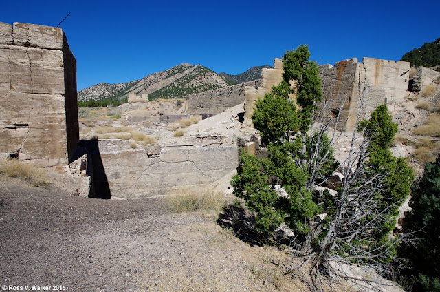
The Knight Mill ruins are a good example.  This massive concrete ruin is on the edge of Silver City, Utah, a ghost town that has nearly completely disappeared.  The smelter was built here in 1907 and it shut down in 1915.
Jesse Knight found several mines in the Eureka, Utah area, including the Humbug and the Iron Blossom lode, so he built this smelter and a railroad to process the ore.  The mill was closed and dismantled when it became more economical to ship ore to a more modern mill.
There are extensive ruins of solution tanks just outside the more massive ruins of the main mill building.  These tanks could be a source of dangerous contamination and should be avoided.
So much of the building has been destroyed that there aren’t many small details to photograph, but there is still some interesting rust on site.  It looks like iron beams were cut off and their stubs left to rust into fantastic shapes.  Is this a nightmarish bird or a bat?
Ore was crushed and mixed with mercury, resulting in an amalgam that had to be heated to separate the valuable metals.  I think this was a kiln used to cook amalgam to separate mercury from gold and silver.  Of course, the kilns could also be a source of contamination that should be avoided.
I like this desert arch, which is probably all that is left of another kiln.  It seems so out of place out there by itself.

While I can’t say that ruins like this are beautiful, like the classical ruins mentioned above, they are interesting and awe inspiring.  They are a big part of our western history, which is disappearing fast, and they deserve to be documented.

All photos are copyrighted and must not be used for any purpose without my permission.

Saturday, January 10, 2015

Bear Lake Valley Fog

Every winter, there is a week or so of heavy fog in the Bear Lake Valley.  If the temperatures are cold enough we are treated to a display of hoarfrost on the trees and fences.  Some years, the temperatures stay low enough to allow the frost to build up over several days to amazing thickness, as I showed in this 2014 post:
http://rosswalkerphotos.blogspot.com/2014/01/hoarfrost-in-bear-lake-valley.html

So far, this year has been a little different because the temperatures have warmed up enough in most places for the frost to melt in the afternoon.  So, every night a thin layer of frost starts to accumulate in the fog over again, but we haven’t had the very thick hoarfrost like last year.


But the fog is still beautiful, and a challenge to photograph.  My autofocus had difficulty with many scenes because objects are so indistinct.  Setting the camera on a single spot focus helped when I placed the sensor on the most distinct area I could find.


I walked around the edge of the golf course in Montpelier, Idaho, then a little way up a steep hill in fairly deep snow, and had the place to myself.  There was more frost here than in some other places, perhaps because the hill blocked the sun quite a while.


Later, Linda and I went out for a ride, looking for more fog scenes, and enjoyed this barn in Bloomington, Idaho.  The fog helped clean up the background clutter, and added some nice frost to the tree.


These big fog events can totally fill the valley with fog, and I had never seen it from above the clouds, so we drove to Garden City, Utah where we could find an overlook.  I wanted to go on an old abandoned road that has a great view, but it has been blocked off, so instead hiked along a ridge in fairly deep snow to get this view.  It is hard to believe that big, beautiful Bear Lake is buried in those clouds.  It was fun to see the valley from a new perspective.

These photos are all copyrighted.  Please do not use them without my permission.

Saturday, December 20, 2014

Christmas At Temple Square


Linda said that one thing on her bucket list was to see the Christmas lights again at Temple Square in Salt Lake City, Utah.  I’m not crazy about visiting the city, but we left our peaceful valley to confront the crowds and traffic.  We saw a Christmas play, “The Forgotten Carols”, ate some great food, shopped, and marveled at the amazing Christmas lights.  I even hiked into the hills to photograph an historic old lime kiln.


Temple Square is a ten-acre park-like location that includes the famous temple, tabernacle, visitor’s center, and more for the Church of Jesus Christ of Latter Day Saints (LDS), often called the Mormon Church.  Linda is a member of the LDS Church, so this visit had extra significance for her.
The Christmas display is one of the best anywhere.  There must be millions of lights, and several pools reflect the colors.  This shot was taken at dusk.

The grounds and buildings are gorgeous.  The Assembly Hall architecture was beautiful in the colorful light.


A tripod is helpful to hold your camera steady for high quality images, but today’s digital cameras can also take beautiful hand held photos after dark using high ISO settings, if you can live with increased digital noise.


A remote shutter release helps minimize camera shake.


This photo was taken at ISO 12800.  

The spectacular display at Temple Square is a wonderful, family friendly place to celebrate the true meaning of Christmas.  There are beautiful reminders everywhere about the birth of Jesus Christ.

All photos are copyrighted by Ross Walker, and cannot be used for any purpose without permission.