Sunday, December 27, 2015

Fremont Indian State Park, Utah

In October 2015 I went on a fall camping trip with my California photography friends.  We met in Ely, Nevada then traveled to Delta, Utah to explore Topaz Japanese Internment Center (see the next post) and the Tintic Mining District.  The last stop was Fremont Indian State Park, Utah, to photograph the Kimberly Mining District and rock art at the Park.

The Fremont Indians lived in central Utah and the surrounding area from about 400 A.D. to 1300 A.D.  It is likely that there were several different tribes, and they may have even had different languages, but their rock art and artifacts set them apart from the nearby Anasazi tribes.  Their culture was named for the Fremont River, which was in turn named for explorer John C. Fremont.
There are hundreds of rock art panels in the park, and we explored several different sites.  One of the most interesting is the Beginning of Life panel located in the Canyon of Life.  Rock Art interpretation is an inexact science, but a Park trail guide states that this petroglyph describes the shape of the canyon and a legend about the sun conceiving life from the east and the west.  Briefly, the sun is shown with its rays, and the center hole represents a natural tunnel in the east side of the canyon.  The sun penetrated the hole and conceived life.  At noon on the summer solstice, a dagger of sunlight goes from the center of the hole to the outer rim of the circle.


The park is in a beautiful location with red rock cliffs, a creek, and views of the Tushar mountains.  We were there in autumn and I enjoyed the fall color in Sam Stowe Canyon and the brilliant squawbush leaves on the Cave of a Hundred Hands trail.


There are actually just 31 hand pictographs in the Cave of a Hundred Hands.  They were made by applying various pigments to the hands and pressing them against the stone.  I posted this photo to Flickr, and received a comment that this is “the most personal kind of pictograph.”  I had never thought of it that way, but now I can imagine the Indians kneeling here as they placed their hand prints on the cave wall.


Petroglyphs along the Parade of Rock Art trail are the most accessible in the park.  This hunting scene shows bighorn sheep, which are common rock art subjects throughout the Fremont culture.  But excavations turn up lots more deer, waterfowl, and rabbit bones than sheep.  Were superstitious artists trying to make the sheep easier to kill by pecking their images in the rock?  Or was a rare successful sheep hunt a reason to brag by creating sheep petroglyphs?


There are also much newer Paiute petroglyphs on the Parade of Rock Art trail.  What could have inspired this “alien” figure?  It was probably created in the late 1880’s.  Older petroglyphs are gradually darkened by oxidation called desert varnish, and since this has no desert varnish we know it is much newer than the Fremont petroglyphs.


The Court of Ceremonies trail is a little more challenging; with a short rock scramble and a brief climb to a ridge that has a good view of the visitor’s center and the Tushar mountains.  There are several interesting anthropomorph (stylized human figure) petroglyphs on the cliffs along the trail.
We also explored the Arch of Art and Sheep Shelter rock art locations, and there were many others that we didn’t get to.  This park is a great place for a family trip to introduce kids to interesting western art and history.  If you would like to see more photos, my Flickr album is here:

Please note that my photographs are all copyrighted and must not be used for any purpose without my permission.

Wednesday, November 25, 2015

Topaz Japanese Internment Center, Utah

During World War II, Japanese people, including American citizens, were taken from their homes and placed in internment camps for the duration of the war.  Generally, these camps were inland, in desolate areas, and the living conditions were primitive to say the least.


I have been to the sites of four of these camps at Manzanar, California; Heart Mountain, Wyoming; Minidoka, Idaho; and now Topaz, Utah on my annual fall camping trip.


Internees were kept under guard behind a barbed wire fence, although many worked outside the fence at a chicken farm, turkey farm, cattle ranch, and other facilities that supported the camp.
There are a few ghostly buildings left at the chicken ranch, but the rest of the camp has been almost completely eradicated.  After the war, buildings were torn down, except for a few that were sold and moved away from Topaz.  The buildings were basic barracks with tar-paper insulation and minimal coal stove heat in a climate that had temperatures below zero in winter and over 100° F in summer.  The area was plagued by high wind and dust storms.

Residents tried their best to make the area livable by creating gardens and planting trees, but the terrible soil and bad weather made it nearly hopeless.  This tree is one of the few left, and the photo shows how all the buildings have disappeared.  If you wander across the desert, you will find foundations, concrete slabs, and an occasional artifact like this toy gun.  But there are no buildings left at the barren site of the camp.


Just imagine – there were about 9000 people living here at one time.  Most of those people lost nearly everything when they were removed from their homes and sent to Topaz or the other camps.  They were forced to sell their homes and belongings on short notice at a great loss because they were not allowed to take much with them to the camps.  Despite all this, 105 men from Topaz volunteered for service in the US military during the war.  One of their units, the famed 442nd, became the most decorated unit for its size and length of service of any unit in US military history!

Now there are several monuments and this flag on one corner of the desolate town site.

The nearby city of Delta has a Topaz museum with a barracks (photo below), recreation hall, artifacts, and best of all, wonderful art work created by internees.  While the actual site of Topaz emphasizes the desolation of living at the camp, the art and artifacts at the museum helped us understand more about what the people were like and how they lived.
I hope the leaders of this country have learned something from the imprisonment of these people.  It is hard to believe that so many people (110,000) were taken from their homes and jobs and placed in camps against their will because of their race.  They were never charged with a crime, and many of them stayed for four years.

I want to thank my camping / photography buddies, Stephen Johnson and Bruce Gregory for all the opportunities to explore unusual, little known, and historic places like this over the last 34 years and 44 camping trips.  It has been great!

All photos are copyrighted and must not be used for any purpose without permission.

Friday, October 30, 2015

Knight Mill, Silver City, Utah

People seem to be attracted to large building ruins.  The Parthenon in Greece, Coliseum in Italy, Machu Picchu in Peru, and Mayan ruins in Central America are all big tourist attractions.  We have our massive ruins here in the American west too, but they are largely ignored except by ghost town hunters.
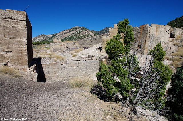
The Knight Mill ruins are a good example.  This massive concrete ruin is on the edge of Silver City, Utah, a ghost town that has nearly completely disappeared.  The smelter was built here in 1907 and it shut down in 1915.
Jesse Knight found several mines in the Eureka, Utah area, including the Humbug and the Iron Blossom lode, so he built this smelter and a railroad to process the ore.  The mill was closed and dismantled when it became more economical to ship ore to a more modern mill.
There are extensive ruins of solution tanks just outside the more massive ruins of the main mill building.  These tanks could be a source of dangerous contamination and should be avoided.
So much of the building has been destroyed that there aren’t many small details to photograph, but there is still some interesting rust on site.  It looks like iron beams were cut off and their stubs left to rust into fantastic shapes.  Is this a nightmarish bird or a bat?
Ore was crushed and mixed with mercury, resulting in an amalgam that had to be heated to separate the valuable metals.  I think this was a kiln used to cook amalgam to separate mercury from gold and silver.  Of course, the kilns could also be a source of contamination that should be avoided.
I like this desert arch, which is probably all that is left of another kiln.  It seems so out of place out there by itself.

While I can’t say that ruins like this are beautiful, like the classical ruins mentioned above, they are interesting and awe inspiring.  They are a big part of our western history, which is disappearing fast, and they deserve to be documented.

All photos are copyrighted and must not be used for any purpose without my permission.

Wednesday, June 3, 2015

Cerro Gordo Revisited

I posted an article on Cerro Gordo on June 4, 2012, so please check it out to learn more about this remarkable ghost town    http://rosswalkerphotos.blogspot.com/2012/06/cerro-gordo-california.html
 
We returned to Cerro Gordo  on April 29 this year, so this is a supplement of sorts.  Caretaker Jim has been replaced by Cat and Matt, but there haven’t been many other changes.  Here they are with my camping buddies, Bruce and Steve, in front of the beautiful American Hotel, which is the oldest hotel still standing in California east of the Sierras.
Cerro Gordo’s old mining town buildings look great in black and white.  The assayer’s building is on the left, and the cribs from Lola’s Palace of Pleasure are on the right.  Cerro Gordo had numerous businesses, including a red light district.
There are artifacts from the mining days scattered everywhere, like these ore bins that used to ride the tram from the mines to the smelter here in town.
The streetlight outside the general store seems to be out of order, and the store is a museum now.

Other odd objects include a worn saddle pommel and a rusty lock.

This view shows some of the water storage tanks that were once needed for a population of 4500. 

When I first started exploring ghost towns, Cerro Gordo was famous, but off-limits.  People could take pictures from the road but had to stay away from the private property.  Fortunately, the Friends of Cerro Gordo now help preserve the town and provide caretakers, so we were able to visit this great old town.

Please note that my photos are copyrighted and cannot be used without my permission.

Saturday, May 23, 2015

Bristlecone Pines, California

A visit to the White Mountains in California to see the bristlecone pines is sure to be an unforgettable experience.  Everything about them is amazing; their spectacular location, their strange shapes, and the statistics about their age.

There is a good, paved road to the visitor’s center, but I was on my annual spring camping trip and we like to find more adventurous routes.  We took the 4WD Silver Canyon Road from Bishop to Patriarch Grove.  The road has four stream crossings and switchbacks up the mountain from 4000’ to 11,000’.


At the top this sign announces the entrance to the Ancient Bristlecone Forest, but there aren’t many trees around, and several more miles of driving on a dirt road will finally get you to Patriarch Grove.

This is a typical scene at Patriarch Grove.  The Bristlecone pines survive in incredibly harsh surroundings.  They grow in alkaline soil that discourages competition from other plants.  They thrive at the tree line in extremely cold, windy conditions, and the area is closed in winter.  Their surreal shapes often include a mix of dead wood and living tree.  Sometimes a narrow strip connecting a root to the crown is all that remains alive in a tree that looks like it died centuries ago.


Great Basin bristlecone pines are the oldest living single organisms on earth!  One recently dated tree here in the White Mountains is 5064 years old.  Its location is secret.  Think of that… many of these trees have been alive for thousands of years before the birth of Christ!


The trees grow extremely slowly because of a lack of water, dry soil, cold temperatures, and short growing seasons.  Their wood is extremely hard, and after death the exposed wood does not rot.  As a result, snags can stand for centuries and their fantastic shapes are created by wind erosion.  The wood is sandblasted and eroded like rock.


This tree took my breath away when I saw it.  I found myself talking to it as I walked around it with my camera.  “You’re beautiful – gorgeous!  You have incredible curves!”  I think I had been out in the desert too long.


Photography is so much fun with these amazing trees.  Their fantastic shapes are irresistibly surreal.  The best days for photographing landscapes of the area will have good sunlight and fluffy clouds, but exposure can be tricky.  HDR is a good tool to pick up detail in the bright clouds while balancing exposure on the trees.  A wide angle lens can be used to exaggerate the bizarre shapes and angles of the eroded snags.
When the fluffy clouds obscure the sun, it is a great time to look for closer photos of wood grain and twisted branches.  A macro lens and tripod is a good choice if you want to get really close.
Black and white is also a great choice to show the wood grain or to show the trees against dramatic high elevation sky.

If you decide to visit the Bristlecones, it is best to be acclimated to the high elevation, especially if you are coming from very low elevation.  So, spend a couple of days in the Bishop area before trying the White Mountains, and don’t overdo it until you are sure you are acclimated.  Be sure to stop at the new visitor’s center at Schulman Grove.  There are more bristlecones to see there and on the strenuous Methuselah Trail.

Please note that all photos are copyrighted and must not be used without my permission.

Monday, May 4, 2015

Alabama Hills, California

The Alabama Hills are a landscape photographer’s paradise; especially if you like rocks.  Millions of rocks.  The hills are located west of Lone Pine, California at the base of the Sierra Nevada Mountains.  Their brown color stands out strongly from the eastern Sierras.
The hills are a relatively barren place with large treeless flats between the huge piles of rocks, so a single tree really stands out.
In this photo, a cottonwood tree survives in the rocks with Lone Pine Peak in the left background.  The more distant, jagged peak directly behind the tree is Mt. Whitney, the tallest mountain in the lower 48 states at 14,505 feet elevation.


The Alabama Hills were named by Confederate sympathizers after the warship CSS Alabama during the Civil War.


The rocks are the same age as the nearby Sierra Nevada Mountains, but were shaped by different chemical weathering caused by percolating water while the rocks were buried.


The Alabama Hills have been popular for filming movies, TV shows and commercials for decades, including Gene Autry, the Lone Ranger, Gunga Din, Tremors, Iron Man and dozens more.


I love to search for arches and “windows” at Alabama Hills.  There must be thousands of them since I have seen dozens in the relatively small area I have explored.  On this trip my favorite was Hitching Post Arch, but the most famous is Mobius Arch, which you can see here from a previous visit:
It is easy to imagine all sorts of creatures in the odd shapes of the rocks and windows.

Lone Pine is a good place to get information about the Alabama Hills, including maps to movie locations and arches, but it is fun to find an interesting pile of rocks and just explore on your own.

These photos are copyrighted and cannot be used for any purpose without my permission.

Monday, April 20, 2015

Eagle Nest

Bald eagles are fairly common here in the Bear Lake Valley, but they usually disappear after the snow melts.  But, for the first time, I found a nest in a dead tree.
I got permission to access the private property where this is located, and learned from the land owner that the nest has been occupied for at least three years.  The eagles turned out to be fairly tolerant of photographers, and would occasionally stay on the nest, but more often would leave.
Would the eagles raise a family this year?  On my fifth visit I saw just one eagle, but she landed on the nest as if sitting on eggs, so I was hopeful.  It was interesting watching her land.  She flew in low and fast then soared straight up and stalled over the nest where she could settle down easily.
Today, on my sixth visit, there was just one eagle, and I think the other has gone away.  This one perched on the branch instead of the nest.  She flew away and returned in a few minutes with a small kill, but ate it on the back side of the tree where I couldn't get photos.  She made no effort to sit on the nest or share food, so I don't think there are any eggs.  Perhaps a recent storm with 65 mph winds ended their nesting for this year.  I look forward to checking next year to see if they return.

All photos are copyrighted and must not be used without permission.

Monday, March 16, 2015

Mysterious Giant Arrows

There are dozens of giant concrete arrows scattered across the landscape of America, and most people don’t know they exist.  It turns out they are part of an old visual navigation system for Air Mail pilots.  In the early days, there was no electronic equipment for navigating aircraft, so in 1924 a system of beacons and arrows was devised by the Postal Service.  50 foot towers with rotating beacons were placed on giant concrete arrows, 50 to 70 feet long that pointed the way to the next beacon and arrow.  Most of them have disappeared now, but it is fun looking for the ones that remain, and there are a few web sites that give location clues.


For many years I have enjoyed searching for, and photographing, interesting and obscure sights across the West, often with long-time camping buddies Bruce Gregory and Stephen Johnson.  Recently they found two of these arrows in the Nevada desert, and since I wasn’t with them I was determined to find one of my own.  Bill Parslow and I found this arrow at Strevell, an Idaho ghost town.

 At one time, a beacon was located on the square patch of concrete on the arrow, but most of the beacons were demolished and the steel used during WWII.  You can see the cut off supports in the first photo.

On the way to Strevell, I spotted this beacon at Malad City Airport.  It strongly resembles the ones used with the arrows, and I believe Malad had an arrow at one time, but I have no idea if this was originally an Air Mail beacon.


We found this arrow after figuring out its location from an image on Google Earth, and were able to drive through a gap in a fence, across a field, and park right next to it.  I took a ladder so we could get a higher angle photo of the arrow.  The concrete ruins at the tail of the arrow housed a generator and fuel to light the beacon.


I hope to be able to search out and photograph more of these mysterious arrows on occasion.


After we were done with the arrow, we photographed this ruin which I later learned was part of Mary’s Café.  There isn’t much more left of Strevell, but we found concrete pads scattered in the sagebrush where there used to be other buildings.  I even found the remains of another beacon and learned that there was once an airport here with a large beacon system.  We celebrated the successful day with pie at Mollie’s Café in Snowville, Utah before the long drive home.

All images are copyrighted and cannot be used for any purpose without permission.

Tuesday, January 20, 2015

Chesterfield In Winter

Chesterfield, Idaho is an agricultural ghost town in the southeastern part of the state.  It was founded in 1880 by Mormon pioneers.  It was a hard place to make a living, and gradually became a ghost town due to drought, harsh winters, and the depression.
Today, Chesterfield is undergoing a revival of sorts as descendants of the early families are restoring the town.  The Chesterfield Foundation recently purchased the beautiful Muir-Butterfield house, and has started restoration by rebuilding the porch.
The LDS Meeting House is probably the best preserved building in town.  When I first started visiting Chesterfield it was a museum, but now it has been restored back to its original form.  In summer, many of the buildings are open for visitors and tours.

In winter, the town is boarded up, deserted, and resting quietly in the snow and cold.  Linda and I visited with three other members of our Sharp Shooters Camera Club.

There is a lot to see and photograph in the quiet of winter.  A restored tractor is parked near the shadow of rusty farm equipment, and interesting details are everywhere.


Old equipment, frosty fences, interesting buildings, ancient gas pumps, snowdrifts – the photo opportunities are wonderful.

The buildings include log cabins, stately brick homes, religious structures, and stores.


A windmill stands alone on a hilltop.


There are 41 buildings in the historic district, and most near the center of town have been restored, but many around the outskirts of town still are in “ghost town” condition, so there is a nice mix of photography subjects.  If you want to see the interiors and talk to knowledgeable people about the town, visit between Memorial Day and Labor Day.  But if you want to see Chesterfield when it is deserted and quiet, visit in the winter.

Please note that all of my photos are copyrighted and must not be used without my permission.